Hurricane Watch: Preparations Urged as Tropical Storm Milton Approaches
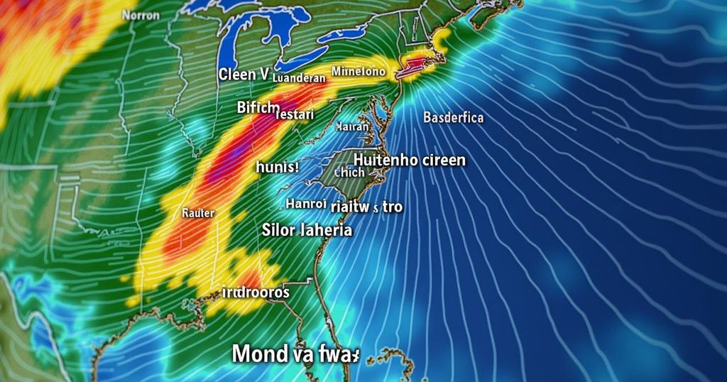
Rain is expected across Southeast Georgia and Northeast Florida this weekend, with cumulative totals of up to 2 inches along the coast. Tropical Storm Milton may strengthen into a category 3 hurricane by Wednesday, posing threats of storm surge and high winds. Preparation for the storm is advised, alongside awareness of flash flood risks and ongoing rip current warnings.
On Saturday evening, temperatures are expected to decline to the mid-70s amidst predominantly cloudy conditions, accompanied by northeast winds ranging from 5 to 10 miles per hour. Rainfall is highly probable in Southeast Georgia and Northeast Florida, with expected accumulations of approximately three-tenths of an inch in Northeast Florida and a quarter of an inch in Southeast Georgia. Over the next three days, coastal areas may receive up to 2 inches of rain, while inland counties, particularly Columbia and Alachua counties, are anticipated to see around a tenth of an inch. Furthermore, rain chances remain significant during the kick-off of the Jaguars game scheduled for 1 p.m. It is imperative to note that the risk of rip currents is projected to remain high throughout the weekend. In terms of tropical activity, Tropical Storm Milton is anticipated to strengthen rapidly as it progresses eastward across the Gulf of Mexico. This storm poses an impending threat to the Gulf Coast of Florida, with indications of storm surge and dangerous winds that could be potentially life-threatening. Current projections indicate that Milton may reach category 3 hurricane status as it approaches land on Wednesday afternoon. Residents of Florida are urged to commence preparations, as the storm’s exact trajectory may fluctuate. Additionally, there are ongoing concerns regarding flash flooding, with current risks ranging from 5% to 15% for Southeast Georgia and Northeast Florida. The likelihood of tropical storm-force winds impacting our area is currently estimated between 20% and 50%. In the Far Eastern Tropical Atlantic, a tropical wave is forecasted to depart the west coast of Africa either on Monday or Tuesday. There exists a possibility of development for this system as it navigates westward or west-northwestward across the eastern tropical Atlantic, with a formation chance assessed at 0% over the next 48 hours, escalating to 30% over the subsequent week.
The article discusses significant weather developments impacting Southeast Georgia and Northeast Florida, focusing on the potential for tropical storm and hurricane conditions due to Tropical Storm Milton. It outlines the forecasted weather leading into the weekend, including temperatures and expected rainfall, while also highlighting the need for preparedness in anticipation of hazardous weather. The inclusion of rip current risks and considerations for flash flooding further underscores the potential for dangerous situations arising from the impending storm.
In conclusion, residents of Southeast Georgia and Northeast Florida should remain vigilant and prepare for potential adverse weather conditions due to Tropical Storm Milton, which could intensify into a hurricane by midweek. With rain expected through the weekend and considerations for possible flash flooding, it is critical for individuals to stay informed and take appropriate safety measures. Furthermore, close attention should be paid to the developments of tropical waves emerging from the Atlantic, as these could also impact local weather patterns in the near future.
Original Source: www.news4jax.com


Post Comment