Tropical Disturbance Invest 94L Monitoring Report by Bryan Norcross
A tropical disturbance labeled Invest 94L is moving westward through unfavorable conditions in the Atlantic, but as it nears the northeastern Caribbean islands by Friday, factors may enhance its development potential. While current development prospects remain low, any changes in the steering currents could impact Puerto Rico and surrounding areas, necessitating continued vigilance among residents.
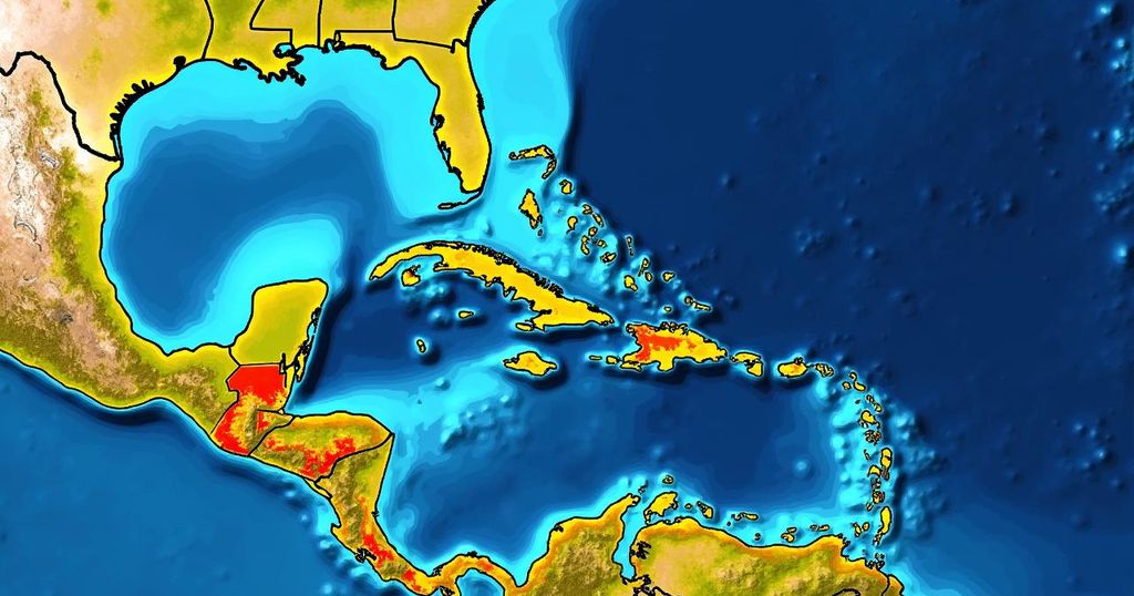
Bryan Norcross has reported that the tropical disturbance identified as Invest 94L continues to progress westward through an environment that is currently unfavorable for development in the central tropical Atlantic. The atmosphere remains significantly dry, hindering the formation of thunderstorms expected to form within this system’s circulation. Over the next few days, development appears unlikely; however, as the system approaches the northeastern Caribbean islands around Friday, improved conditions for development may arise. It is quite atypical for a tropical disturbance originating from Africa to reach the Caribbean region during this period of the year. Generally, ocean waters begin to cool, upper-level winds become more adverse, and frequent dips in the jet stream tend to redirect systems towards the north. Currently, the system’s unusual trajectory is influenced by warmer ocean temperatures and a persistent high-pressure area situated just north of the disturbance. Satellite imagery suggests that some elevated thunderstorms are attempting to develop near the center of the otherwise disrupted circulation currently present. The National Hurricane Center has assigned a medium probability for the system to develop into at least a tropical depression by the time it reaches the waters near or just north of Puerto Rico or the adjacent islands. There is substantial agreement among computer forecast models indicating that the disturbance will be in that vicinity around Friday; however, the potential for organization may vary from a mere surge of moisture to a more robust system with a well-formed circulation. Following Friday, the expected light steering currents may allow the system to drift in proximity to Puerto Rico, the Dominican Republic, Haiti, or the southeastern Bahamas, where potential impacts from a tropical storm or hurricane cannot be dismissed. Nevertheless, when the steering flow is poorly defined, uncertainty regarding the track increases. Therefore, it is advisable for residents in Puerto Rico, the Virgin Islands, Hispañola, the southeastern Bahamas, and surrounding islands to remain vigilant this week. Currently, there does not appear to be a significant threat to Florida, which has recently experienced hurricane season fatigue. A cold front moving across or near South Florida, coupled with a developing dip in the jet stream over the Bahamas, is likely to prevent any tropical systems from affecting the state. It is prudent, however, to allow the disturbance to become better organized, as this will lead to increased confidence in forecasting its potential path. As always, it is important to recognize that predictions regarding the strength and trajectory of undetermined or newly developing systems carry substantial uncertainty and may evolve over time.
The Atlantic hurricane season typically sees fluctuations in weather patterns and tropical disturbances. Invest 94L is currently being monitored as it traverses an area characterized by dry air, which generally inhibits the formation of strong storms. This unusual weather pattern is notable as such disturbances typically face increased ocean cooling and adverse upper-level winds during this time of year. Meteorologists examine atmospheric conditions and models to assess potential development, particularly as systems approach landmasses like Puerto Rico and the surrounding islands.
In summary, while the tropical disturbance Invest 94L currently travels through a dry atmosphere with low chances for development in the immediate days ahead, conditions may become more favorable by Friday as it approaches the northeastern Caribbean. Residents in susceptible areas should stay aware of evolving weather forecasts. The situation remains fluid, and uncertainties in the system’s eventual path emphasize the importance of careful monitoring.
Original Source: www.foxweather.com


Post Comment