The Unforeseen Rise of Hurricane Oscar: A Study in Meteorological Model Limitations
Hurricane Oscar rapidly intensified from a tropical wave with a 10% chance of development on Friday, to a Category 1 hurricane by Saturday, surprising meteorological models. Human observers and reconnaissance missions played critical roles in identifying the storm’s strength and issuing timely warnings, leading to an under 24-hour preparedness time for impacted areas, showcasing the inherent difficulties in forecasting small tropical systems effectively.
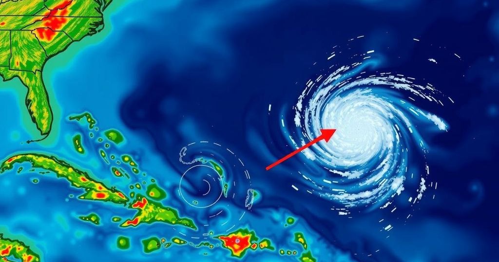
On Friday evening, a disorganized tropical wave situated to the east of Puerto Rico possessed only a 10% likelihood of intensifying over the weekend. However, by midday Saturday, this same system had escalated into a Category 1 hurricane, ominously approaching the Bahamas. What transpired during this rapid transformation? According to experts, the diminutive storm had eluded the detection of numerous major forecasting models. Yet, human observers, alongside pilots and researchers collecting data, promptly raised alarms ahead of Hurricane Oscar’s impending landfall. Philippe Papin, the on-duty forecaster at the National Hurricane Center on Saturday morning, identified anomalies in the passive microwave imagery—a satellite tool that provides insights beneath cloud cover. He detected the emergence of a low-level circulation, which is indicative of a developing tropical storm. “It became pretty clear that a small circulation was developing,” stated Papin. “We had to shift gears in a short period of time.” By 11 a.m., the hurricane center issued its inaugural forecast for Tropical Storm Oscar, pinpointing a trajectory aimed directly at the Bahamas and Cuba. Consequently, the Bahamas issued a tropical storm warning. Concurrently, a hastily assembled team of Hurricane Hunters took flight from St. Croix. Upon reaching the storm area, they encountered a system considerably more potent than anticipated, as the aircraft did not detect tropical-storm-force winds until it was within 10 nautical miles of the center. Within a short time frame, by 2 p.m., Tropical Storm Oscar had metamorphosed into Hurricane Oscar, notably classified as one of the smallest hurricanes recorded in the Caribbean, affording the affected regions less than a full day to prepare for the severe weather. Papin remarked, “The typical time for issuing a watch is 48 hours of lead time. This was more like 12 to 24 hours. Obviously that is sub-optimal.” Ultimately, Hurricane Oscar made landfall on Great Inagua Island in the Bahamas early Sunday morning and subsequently impacted the eastern coast of Cuba that evening. Examining the shortcomings of forecasting models, the system that would evolve into Oscar initially departed the African coast over a week ago. Although early models indicated a fair potential for the formation of a tropical depression, the advent of dry air was expected to diminish its likelihood of development. Even the reconnaissance missions confirmed the system remained merely a tropical wave as of Friday, leading to no significant forecast adjustments signaling the potential for such a storm within the Caribbean or Atlantic for the upcoming week. By Saturday, however, this prognosis had dramatically changed. Phil Klotzbach, a senior research scientist at Colorado State University, noted, “I think the models just had a hard time resolving the circulation before they got the recon in there. It’s not like the models didn’t have signals; they had them and then it killed them off.” Following the reconnaissance flight, the data collected was rapidly integrated into the modeling systems, allowing forecasters like Papin to recalibrate their predictions. They then began to reflect the magnitude of Hurricane Oscar, whose winds extended a mere 5 nautical miles from its center. Given Oscar’s compact size—evident in its relatively small radius of wind influence—it posed unique forecasting challenges. Historically, the National Hurricane Center has tracked various storm sizes, with Oscar’s initial radius being 34 nautical miles, juxtaposed against the record small storms Humberto (2007) and Jeanne (2004), which had radii of 26 and 28 nautical miles, respectively. Klotzbach remarked about the inherent complexities in forecasting such small systems, stating, “Even though it’s low, they always had a 10% chance. You just never know. It’s a tough forecast. These small storms are tricky. This case underscores the difficulties associated with forecasting tropical storms, especially those that develop quickly and are challenging to track due to their size and other environmental factors.
Hurricane forecasting relies heavily on computer models that analyze environmental conditions to predict storm behavior. These models utilize various data sources including satellite imagery and reconnaissance flights, which gather real-time information about a storm’s structure and intensity. The case of Hurricane Oscar highlights the limitations of these models, particularly in recognizing the potential development of small storms that may not present strong indicators in the initial stages. Scientists are constantly refining their techniques to improve prediction accuracy, particularly for systems that exhibit rapid intensification or possess unique characteristics that escape standard modeling assumptions.
The emergence of Hurricane Oscar from a minimal tropical wave into a formidable Category 1 hurricane within a short timeframe demonstrates the unpredictability of meteorological forecasting. While computer models initially failed to account for the storm’s development, timely human observation and reconnaissance efforts enabled forecasters to issue alerts and warnings. This incident serves as a reminder of the inherent challenges in predicting the behavior of small tropical systems, emphasizing the need for continual advancements in forecasting methodologies.
Original Source: www.miamiherald.com


Post Comment