Cyclone Chido Strikes Mayotte: A Historical Devastation
Tropical cyclone Chido struck Mayotte on December 14 with winds over 200 km/h, leading to significant destruction and loss of life, despite advance warnings. It was the strongest storm in 90 years for Mayotte and subsequently impacted Mozambique. Météo-France highlighted uncertainties surrounding climate change’s role in this event. The 2024-2025 cyclone season is projected to witness above-normal activity in the region.
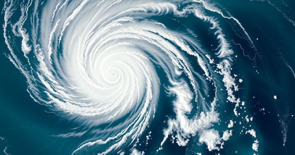
Tropical cyclone Chido made landfall on Mayotte on December 14, unleashing winds exceeding 200 kilometers per hour and gusts surpassing 225 kilometers per hour, marking it as the most formidable storm to impact Mayotte in nearly a century, as stated by Météo-France. Accompanying the fierce winds were torrential downpours, with an astonishing 176 millimeters of rain recorded within a 12-hour period, and perilous sea conditions characterized by average wave heights exceeding 5 meters. The cyclone’s intensity was such that it caused significant damage, including the destruction of Météo-France’s observation facilities.
In the wake of this disaster, French President Emmanuel Macron proclaimed a national mourning period. Reports indicated that the small island, which generally does not experience such powerful tropical cyclones, may have suffered significant casualties, particularly due to the presence of numerous informal housing structures. This tragedy unfolded despite timely warnings from Météo-France, who issued alerts 50 hours prior, commencing with an amber alert on December 13 and escalating to a rare violet alert on the morning of December 14.
Cyclone Chido took an atypical path, avoiding the larger island of Madagascar, which might have tempered its strength. Instead, it struck Mayotte directly, with the cyclone’s eye encircling the island completely. Following its impact on Mayotte, Chido proceeded to make landfall in Mozambique on December 15, resulting in heavy rainfall in both Mozambique and Malawi. Météo-France notes the unclear influence of climate change on this phenomenon, emphasizing that the intensity and track of Chido are primarily attributed to its direct impact on Mayotte, an unprecedented event not observed for 90 years.
Additionally, Météo-France La Réunion operates as the World Meteorological Organization’s Regional Specialized Meteorological Centre for tropical cyclones in the South-West Indian Ocean. Their seasonal forecast, issued on October 31, accurately predicted an earlier start to the cyclone season for 2024-2025, marking a shift from recent years where tropical systems typically began impacting in January. Their outlook anticipates near-normal to above-normal cyclone activity, estimating 9 to 13 systems, with 4 to 7 expected to reach tropical cyclone intensity, thereby raising awareness of potential future cyclonic events.
Tropical cyclones, or hurricanes in some regions, are severe storm systems characterized by low pressure, high winds, and heavy rainfall. These phenomena are particularly impactful in areas such as the Indian Ocean, where islands, like Mayotte, can be vulnerable to such extreme weather events. Cyclone Chido’s unprecedented intensity and its direct hit on Mayotte highlighted the ongoing discussion about climate change’s potential impact on the frequency and severity of tropical cyclones. Météo-France serves as a key authority in forecasting and monitoring these events in the region.
The devastation wrought by cyclone Chido on Mayotte exemplifies the potential severity of tropical cyclones in vulnerable regions, particularly where infrastructure may not withstand such impacts. Despite prior warnings, the cyclone’s unprecedented intensity led to tragic loss of life, indicating the need for improved preparedness and resilience strategies. Furthermore, the discussion regarding the role of climate change in such events remains complex and requires ongoing research to better understand these phenomena.
Original Source: wmo.int


Post Comment