Waza National Park: A Glimpse of Biodiversity from Above
The Sentinel-2 mission has captured an aerial image of Waza National Park in northern Cameroon, highlighting its biodiversity and ecological significance. The park, designated a UNESCO World Heritage site, supports diverse wildlife and is surrounded by the Logone floodplain, which relies on seasonal flooding. Local communities depend on this ecosystem for their livelihoods. The image reflects the region’s fertility as floodwaters recede and shows the surrounding landscapes adjusting to the dry season.
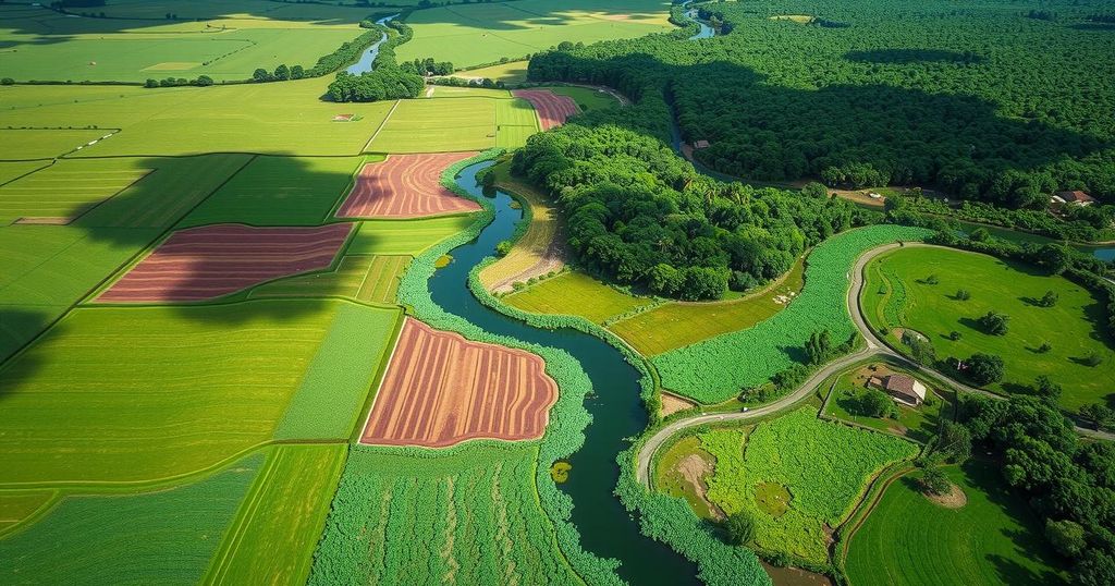
The Copernicus Sentinel-2 mission has captured a remarkable aerial view of Waza National Park in Cameroon, showcasing its stunning landscape. This park is situated in Cameroon’s northernmost region, bordered by Chad to the east and Nigeria to the west, covering an impressive area of 1,700 square kilometers, merely 10 kilometers from the borders of both countries.
Waza National Park, depicted on the left side of the image’s green area, is renowned for its biodiversity, serving as a sanctuary for various wildlife, including lions, elephants, giraffes, and a plethora of bird species. In recognition of its ecological significance, it was designated a UNESCO World Heritage biosphere reserve in 1979.
Adjacent to the park is the town of Waza, identifiable as a small yellowish patch bordered by lush green land. The expansive green areas surrounding Waza National Park are part of the Logone floodplain, which is one of several floodplains within the Lake Chad basin. Seasonal flooding from the Logone River, depicted by its brown winding line to the east, contributes to the verdant landscape and lies along the Cameroon-Chad border.
The ecology of this region is influenced by alternating dry and wet seasons. From mid-May to mid-October, during the rainy season, the area transforms into a temporary wetland, fostering rich growth of grasses and reeds. Over 100,000 local inhabitants depend on this annual flooding cycle for fishing, agriculture, and grazing, with agricultural patches notably visible in the image, particularly the largest field to the left of the Logone River.
The image was captured in November 2024, a time when floodwaters begin to recede, highlighting the region’s fertility as it remains green. The onset of the dry season is noticeable, as conservation efforts in the park contrast with the nearby agricultural lands, which show signs of being post-harvest and fallow, marked by brown tones. Furthermore, the Chari River, Lake Chad’s primary tributary, is visible on the right; it meets the Logone River to the north before ultimately flowing into Lake Chad, which is not depicted but located further north. In proximity, the capital city of Chad, N’Djamena, is apparent as a large grey area at the top of the image.
In conclusion, the aerial view of Waza National Park reveals its ecological significance and rich biodiversity, which includes a diverse range of wildlife and supporting floodplain ecosystems. The cyclic nature of the environment, shaped by seasonal flooding, plays a critical role in sustaining local communities reliant on agriculture and fishing, as well as contributing to the region’s natural beauty. This depiction from the Sentinel-2 mission emphasizes the importance of preserving such vital landscapes for future generations.
Original Source: www.esa.int


Post Comment