Fading Odds for October Named Storms in the Atlantic and Emerging Cyclonic Activity in the Indian Ocean
The Atlantic hurricane season appears to be settling, with low probabilities of new named storms, while two tropical disturbances are being monitored. One disturbance, Invest 94L, faces significant challenges to development due to unfavorable environmental conditions. Meanwhile, a second system is predicted to cause heavy rainfall in Belize and southern Mexico. Additionally, the North Indian Ocean is anticipated to experience cyclonic activity as its October season begins.
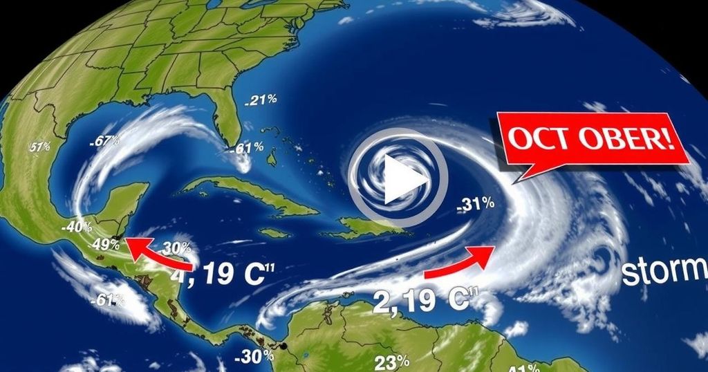
As we progress into October 2024, the frequency of named storms in the Atlantic appears to diminish, following an initial burst of activity early in the month. Presently, there are two tropical disturbances being monitored, both exhibiting low probabilities of evolving into named storms. Forecasters suggest that Hurricane Milton might be the last named storm of the month. Nevertheless, a new pulse from the Madden-Julian Oscillation (MJO) expected in early November may create conditions conducive for hurricane formation, indicating that we should refrain from prematurely concluding the hurricane season. Invest 94L, a tropical disturbance positioned near the Leeward Islands, is advancing westward at a speed of approximately 20 mph. Factors such as light wind shear and unusually warm ocean temperatures of 30 degrees Celsius (86°F) seem to support potential development; however, the disturbance is ensnared in a dry air mass that has curtailed significant thunderstorm activity. The rapid forward motion of 94L hinders its ability to synchronize its upper-level and surface centers, further complicating development prospects. On Saturday, 94L faces two major inhibiting factors: adverse wind shear should it chart a course towards Florida, or the challenging terrain of Hispaniola if it steers west-southwest towards the Dominican Republic. Weather models express skepticism regarding 94L’s chances and predict its dissolution by Sunday, although it may still generate heavy rain—estimations suggest 1-2 inches (25-50 mm)—across the Leeward Islands, the Virgin Islands, Puerto Rico, and the Dominican Republic from Friday through Saturday. In its 8 a.m. EDT Thursday Tropical Weather Outlook, the National Hurricane Center assigned 94L a 20% likelihood of development within two days and a 30% likelihood over a week, with the next named storm on the Atlantic list being Nadine. A second system, associated with a Central American Gyre, is likely to cause intense rain in areas such as Belize and southern Mexico, despite a scant chance of developing into a tropical cyclone before making landfall. This disturbance, located about 50 miles off Honduras’s northeast coast, shows signs of disarray but is expected to traverse warm sea surface temperatures of 29-30 degrees Celsius (84-86°F). It, too, will encounter strong upper-level winds that may hinder any development potential. As of Thursday at 8 a.m EDT, the disturbance received a 20% probability of developing in the next two to seven days, but with little time remaining before it moves inland. Regardless of its formation, the system is predicted to produce significant rainfall, potentially exceeding 15-20 inches in various locations, thereby elevating flash flood and mudslide risks throughout Belize and southeastern Mexico. Simultaneously, the North Indian Ocean is entering its cyclonic season, characterized by two seasons—one in May preceding the monsoon and another from October through November following its decline. This season is expected to gain momentum soon due to favorable MJO conditions in the region, with predictions indicating the formation of a tropical cyclone in the eastern Bay of Bengal. Historical context reveals that the last significant cyclone, Cyclone Mocha, struck Myanmar on May 14, 2023, leading to devastating effects and considerable loss of life amidst the backdrop of a civil war in the country that aggravates the overall humanitarian situation.
The Atlantic hurricane season typically peaks from June to November, with October often serving as a pivotal month for tropical cyclone formation. The Madden-Julian Oscillation (MJO) represents an important climatic factor influencing weather patterns, particularly the development of storms. Tropical disturbances in the Atlantic region can vary significantly based on environmental conditions, including wind shear, sea surface temperatures, and atmospheric moisture availability. Hence, careful monitoring is critical during this active period for potential named storm formations. Meanwhile, the North Indian Ocean also experiences tropical cyclones post-monsoon, with historical events highlighting the impact of cyclones on both human lives and infrastructure.
In summary, while the prospects for additional named storms in the Atlantic diminish as October progresses, ongoing monitoring of two disturbances remains essential. The upcoming influence of the Madden-Julian Oscillation may offer further opportunities for cyclone development. Concurrently, the impending cyclonic season in the North Indian Ocean signals potential for increased activity in the coming weeks. The overarching theme emphasizes the importance of vigilance and preparedness during hurricane and cyclone seasons.
Original Source: yaleclimateconnections.org


Post Comment