Declining Chances for Tropical Storm Nadine as NHC Alerts on Invest 94L
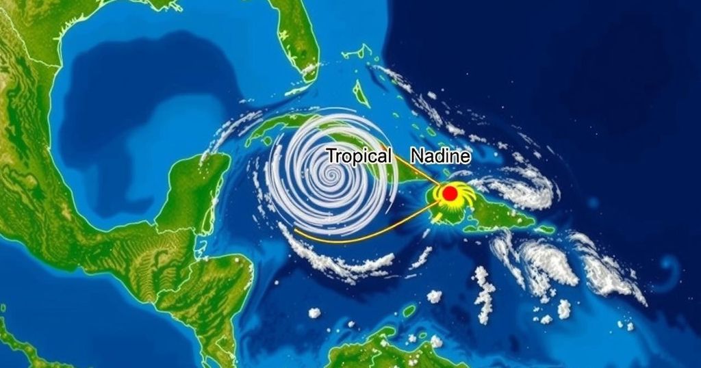
The National Hurricane Center reports declining chances for the formation of Tropical Storm Nadine, as Invest 94L’s development odds diminish. A western Caribbean disturbance may develop but is expected to move inland, producing rainfall in Central America. Florida will likely remain unaffected due to strong wind shear, though coastal residents should prepare for rough surf and potential flooding.
Residents of Florida can find comfort in the diminishing likelihood of the formation of Tropical Storm Nadine, as indicated by the National Hurricane Center (NHC). Over the past week, the NHC has closely monitored two tropical disturbances situated in the Atlantic Ocean and the western Caribbean Sea. The disturbance labeled Invest 94L, which appeared to be the most probable candidate for developing into Tropical Storm Nadine, has seen a steady decline in its development chances throughout the week. The western Caribbean disturbance may still exhibit some development in the coming days, yet the potential remains low as it is projected to move inland across Central America, triggering significant rainfall in that region and parts of southern Mexico over the weekend. Fortunately, Florida is expected to remain shielded from any developments stemming from these systems due to strong wind shear that, according to AccuWeather, will likely disrupt and break apart any tropical systems that attempt to approach the southeastern United States. Currently, Invest 94L persists as a low-pressure trough, generating disorganized showers and thunderstorms a few hundred miles east of the Leeward Islands. Although some gradual development is anticipated as the system progresses westward to west-northwestward at approximately 20 mph—passing near Puerto Rico and the Virgin Islands on Friday and approaching Hispaniola and the southeastern Bahamas on Saturday—strong upper-level winds are projected to inhibit further development by late in the weekend. Meanwhile, the tropical disturbance originating from the gyre in the western Caribbean Sea is anticipated to witness slight development prior to its landfall in Central America this weekend, with formation chances assessed at a mere 20%. Regardless, this disturbance is expected to bring locally heavy rainfall to portions of Central America and southern Mexico. While conditions in the tropics appear relatively stable compared to recent weeks, residents along Florida’s Atlantic coast should remain cautious of the adverse effects of strong wind shear. Persistent northeast breezes may result in tumultuous surf and tides exceeding predicted astronomical levels, potentially leading to coastal flooding and beach erosion. Particularly vulnerable cities, such as Miami, may experience considerable overwash and street flooding during high tide scenarios, as noted by AccuWeather Senior Meteorologist Brett Anderson. As the 2024 Atlantic hurricane season approaches its conclusion on November 30, residents are encouraged to stay vigilant and informed about ongoing weather conditions.
The article addresses the recent updates regarding Tropical Storm Nadine and its associated disturbances, monitored by the National Hurricane Center. It highlights the changing chances of development of the storms, particularly focusing on Invest 94L and a disturbance in the western Caribbean Sea. This information is crucial for residents of Florida and surrounding areas, as it discusses both the potential weather impacts and safety precautions amid evolving tropical systems. Furthermore, the article outlines the expected weather patterns and protective measures for coastal regions in light of projected wind shear effects.
In summary, the chances of Tropical Storm Nadine’s formation are decreasing, as the NHC has noted a steady decline in the development potential of Invest 94L. Although the western Caribbean tropical disturbance exhibits some likelihood of development, it is unlikely to pose a substantial threat to Florida, thanks to strong wind shear disrupting storm systems. Residents, especially along the Atlantic coast, should remain alert to the rough surf conditions and flooding risks associated with persistent winds. As the active hurricane season nears its end, due diligence and preparedness remain essential for local populations.
Original Source: www.pnj.com


Post Comment