Tropical Cyclone Chido: A Historic Storm Impacts Agalega and Beyond
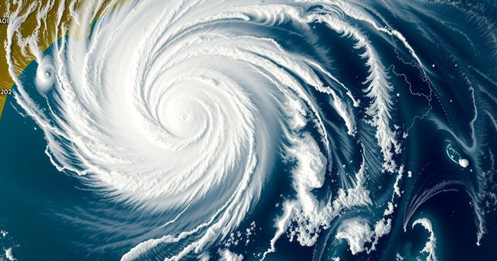
Tropical Cyclone Chido has intensified to become the strongest cyclone to strike Agalega, Mauritius, in over 50 years. With wind speeds reaching up to 222 km/h (138 mph), it made landfall on December 12, 2024. The cyclone is now predicted to impact northern Madagascar, Mayotte, and Mozambique, leading to warnings of severe weather, including heavy rainfall and strong winds in these regions.
Tropical Cyclone Chido formed on December 10, 2024, in the Southwest Indian Ocean Basin and rapidly intensified before making landfall on Agalega, Mauritius. Measuring as the strongest cyclone to impact the island in over four decades, Chido recorded wind speeds soaring up to 222 km/h (138 mph) and struck Agalega at 00:00 UTC on December 12 as a category 4-equivalent tropical cyclone. As it progresses, Chido is projected to brush past northern Madagascar and approach Mayotte, ultimately making landfall near Nacala, Mozambique, on December 15.
Following its formation, Chido exhibited rapid intensification, with winds escalating from 111 km/h (69 mph) to an impressive 222 km/h (138 mph) within just 24 hours. The cyclone’s landfall on Agalega marked a significant event, as it became the most potent storm to impact the island since Cyclone Andry in 1983, which was catastrophic. Current forecasts suggest that Chido will pass near Mayotte and the northeastern coast of Mozambique, where it is expected to produce rainfall, strong winds, and coastal flooding.
As Chido closely approaches Madagascar and Mayotte, heavy rain, potentially destructive winds, and dangerous sea conditions are anticipated. For northern Madagascar, the deterioration of weather conditions is forecasted to commence on Friday morning, while Mayotte has been placed on cyclone pre-alert. Notably, the systems’ wind speeds are expected to create hazardous coastal conditions across the archipelago of Comoros as well.
Although there remains uncertainty regarding specific impact zones in Mozambique, residents are advised to adhere to official warnings and closely monitor updates from national meteorological services. As of December 12, Chido was positioned approximately 920 km (570 miles) ENE of Mayotte and was advancing westward at 22 km/h (14 mph).
Cyclone Chido represents the third named storm of the 2024/25 Southwest Indian Ocean Cyclone season, emphasizing the critical nature of monitoring tropical cyclones in this region. The cyclone’s rapid intensification and strong winds highlight the unpredictable behavior of storm systems in tropical regions. Past cyclones, especially Cyclone Andry in 1983, demonstrate the severe impacts such storms can have on vulnerable islands like Agalega, ensuring that residents and regional meteorological authorities are on high alert during these events. The trajectory of Tropical Cyclone Chido will impact several areas, especially Madagascar and Mozambique, both of which are no strangers to extreme weather. Historical data illustrates the need for preparedness as heavy rainfall and destructive winds threaten these coastal regions. Understanding the cyclone’s potential path and strength is crucial to mitigate risks and safeguard lives and property.
In conclusion, Tropical Cyclone Chido has emerged as a formidable weather event within the Southwest Indian Ocean, marking a significant threat to Agalega, Madagascar, Mayotte, and Mozambique. With its rapid intensification and projected path toward populated areas, residents in these regions must remain informed and vigilant. Official forecasts and alerts are essential to ensure safety against the anticipated severe weather conditions associated with the cyclone, highlighting the importance of preparedness in the face of natural disasters.
Original Source: watchers.news


Post Comment