Weather
World news
AFRICA, AGENCE FRANCE - PRESSE, ATLANTIC, ATLANTIC BASIN, CHI, COLOMBIA, EMILY CASSIDY, EVACUATIONS, GRANDE TERRE, JESS ZIMMERMAN, LANDSAT, MICHALA GARRISON, NATURAL DISASTER, NATURAL DISASTERS, NORTH AMERICA, PUERTO RICO, RAIN, SOUTH AMERICA, U. S. GEOLOGICAL SURVEY, UNIVERSITY OF, UNIVERSITY OF PUERTO, WEATHER
Fatima Khan
0 Comments
Devastation on Mayotte Following Cyclone Chido
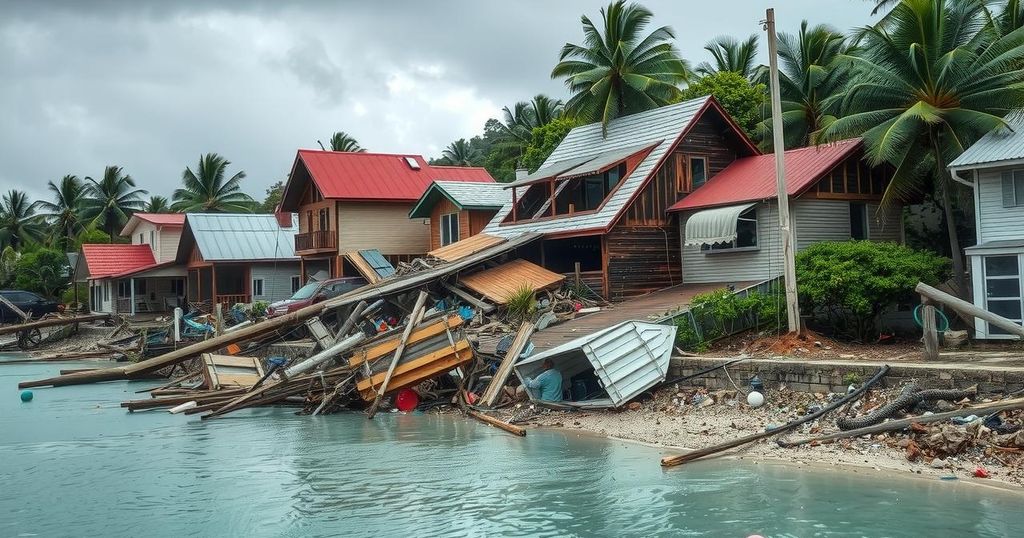
Cyclone Chido struck Mayotte on December 14, 2024, causing extensive damage to homes, infrastructure, and vegetation. The storm’s hurricane-force winds left the landscape brown and disrupted vital services. Satellite imagery revealed severe impacts, particularly in the hills near Mamoudzou, raising concerns about food security due to the destruction of crops. Reports indicated that significant trees and agricultural areas sustained irreversible damage, prompting humanitarian assessments of the situation.
On December 14, 2024, Cyclone Chido struck the islands of Mayotte, resulting in significant devastation across the French territory located off the southeast coast of Africa. The cyclone unleashed hurricane-force winds that ripped roofs from homes, uprooted trees, and toppled utility poles, transforming the once lush landscape into a barren sight. Satellite imagery captured two weeks post-cyclone highlights the extensive damage to vegetation, particularly in the hills near Mamoudzou, the island’s capital.
Jess Zimmerman, an ecology professor at the University of Puerto Rico, who has researched the effects of hurricanes on vegetation in the Atlantic, noted that similar impacts were observed on landforms in the southwest Indian Ocean, which includes Mayotte. The satellite images taken by Landsat 8 illustrate a dramatic change, where the greenery of two months prior has been largely replaced by browning foliage following the storm.
The cyclone’s high winds inflicted severe harm by stripping leaves and breaking branches, while the saturated soil facilitated tree uprooting. Additionally, the destruction extended to critical infrastructure on the islands with significant damage reported to the airport, healthcare facilities, and roadway systems, impeding access to essential utilities such as electricity, water, and communications.
Agence France-Presse reported notable incidents related to Cyclone Chido, including the collapse of a 300-year-old giant baobab tree and the uprooting of an acacia tree, which left a substantial mound of soil in its wake. The storm devastated local agriculture, destroying banana trees and threatening the food security of island communities, as detailed in a humanitarian assessment following the disaster. Moreover, European Commission satellite evaluations confirmed that the northeast part of Grande Terre experienced the worst of the cyclone’s destructive forces.
Cyclone Chido is classified as a significant meteorological event, with its impact being particularly severe given the geographic and environmental characteristics of Mayotte. The island is located in a region prone to cyclones, specifically within the southwest Indian Ocean. The destruction caused by such storms can lead to long-term ecological shifts and societal challenges, particularly regarding food safety and infrastructure resilience. Understanding the aftermath of Cyclone Chido requires an examination of both ecological and humanitarian assessments, as they reveal the extensive implications on local communities and the environment following extreme weather events.
In conclusion, Cyclone Chido’s landfall on Mayotte has dramatically altered the island’s landscape, leading to substantial ecological damage and risk to food supplies. The storm has also severely affected core infrastructures, disrupting essential services for the local population. As the region begins to recover, the analysis of both immediate and long-term impacts will be imperative to support rebuilding efforts and to strengthen resilience against future cyclonic activity.
Original Source: earthobservatory.nasa.gov


Post Comment